Geolocate

Broken Hand Peak topographic map

Click on the map to display elevation.

About this map

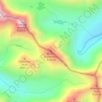
Name: Broken Hand Peak topographic map, elevation, terrain.

Location: Broken Hand Peak, Custer County, Colorado, United States (37.95689 -105.56673 37.95699 -105.56663)

Average elevation: 3,757 m

Minimum elevation: 3,393 m

Maximum elevation: 4,326 m

Other topographic maps

Click on a map to view its topography, its elevation and its terrain.

Westcliffe

United States > Colorado > Custer County

Average elevation: 2,404 m

Silver Cliff

United States > Colorado > Custer County

Average elevation: 2,455 m

Gear up for your next adventure:

❄️Traction Ice Cleats - Slip-on spikes for icy trails and winter hiking
👟Sport Hiking Sandals - Breathable footwear for water crossings and camp rest
Tent Footprint - Protect tent floor and increase durability
🚲Heavy Duty Bike Lock - Secure your bike at the trailhead or during stops
🥤Collapsible Travel Cup - Saves space and weight in your mess kit

As an Amazon Associate, this site earns from qualifying purchases at no extra cost to you.