
Thank you for supporting this site ❤️
Make a donation
Make a donation
Gear up for your next adventure:
As an Amazon Associate, this site earns from qualifying purchases at no extra cost to you.
Tanos topographic map
Click on the map to display elevation.
Thank you for supporting this site ❤️
Make a donation
Make a donation
Gear up for your next adventure:
As an Amazon Associate, this site earns from qualifying purchases at no extra cost to you.
Tanos
Tanos se encuentra a una altitud de 26 metros sobre el nivel del mar, y dista 26 kilómetros de Santander.
Thank you for supporting this site ❤️
Make a donation
Make a donation
Gear up for your next adventure:
As an Amazon Associate, this site earns from qualifying purchases at no extra cost to you.
About this map
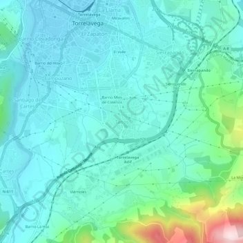
Name: Tanos topographic map, elevation, terrain.
Location: Tanos, Torrelavega, Cantabria, 39300, España (43.31246 -4.06380 43.35246 -4.02380)
Average elevation: 87 m
Minimum elevation: 12 m
Maximum elevation: 433 m
Thank you for supporting this site ❤️
Make a donation
Make a donation
Gear up for your next adventure:
As an Amazon Associate, this site earns from qualifying purchases at no extra cost to you.