Geolocate

Busnago topographic map

Click on the map to display elevation.

About this map

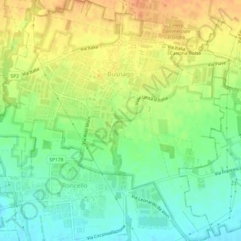
Name: Busnago topographic map, elevation, terrain.

Location: Busnago, Monza and Brianza, Lombardy, Italy (45.59558 9.44258 45.62524 9.48491)

Average elevation: 204 m

Minimum elevation: 186 m

Maximum elevation: 222 m

Other topographic maps

Click on a map to view its topography, its elevation and its terrain.

Sant'Alessandro

Italy > Lombardy > Monza and Brianza > Villasanta

Average elevation: 184 m

Mombello

Italy > Lombardy > Monza and Brianza > Limbiate > Mombello

Average elevation: 207 m

Sant'Albino

Italy > Lombardy > Monza and Brianza > Monza > Sant'Albino

Average elevation: 159 m

Gear up for your next adventure:

🦶Hiking Shoe Insoles - Added support for high arches and long days on feet
🧼Biodegradable Camp Soap - Environmentally friendly cleaning for gear and body
🩹Compact First Aid Kit - Pre-packed essentials for common trail injuries
🥾Trail Hiking Socks - Comfortable socks to prevent blisters and fatigue
💡Compact LED Flashlight - Powerful and portable flashlight for outdoor use

As an Amazon Associate, this site earns from qualifying purchases at no extra cost to you.