
Make a donation
Gear up for your next adventure:
As an Amazon Associate, this site earns from qualifying purchases at no extra cost to you.
Monistrol-sur-Loire topographic map
Click on the map to display elevation.
Make a donation
Gear up for your next adventure:
As an Amazon Associate, this site earns from qualifying purchases at no extra cost to you.
Monistrol-sur-Loire
Rond het jaar 900 bestond er al een parochie in Monistrol. Die kreeg relieken van de heilige Marcellin toevertrouwd. Rond het jaar 1000 werd een burcht gebouwd op een hoogte boven de kerk. In het midden van de 12e eeuw werd een nieuwe, romaanse kerk gebouwd, waarvan delen nog te zien zijn in de huidige kerk. De heer van Monistrol was vanaf 1270 de bisschop van Le Puy-en-Velay, die regelmatig in Monistrol resideerde in het bisschopskasteel (château des Évêques). Dit 13e-eeuws kasteel werd uitgebreid in de 15e en in de 17e eeuw.
Make a donation
Gear up for your next adventure:
As an Amazon Associate, this site earns from qualifying purchases at no extra cost to you.
About this map
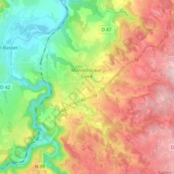
Name: Monistrol-sur-Loire topographic map, elevation, terrain.
Average elevation: 629 m
Minimum elevation: 432 m
Maximum elevation: 868 m
Make a donation
Gear up for your next adventure:
As an Amazon Associate, this site earns from qualifying purchases at no extra cost to you.
Other topographic maps
Click on a map to view its topography, its elevation and its terrain.
Les Ardennes
Frankrijk > Auvergne-Rhône-Alpes > Haute-Loire > Saint-Julien-Chapteuil
Average elevation: 1,090 m
Make a donation
Gear up for your next adventure:
As an Amazon Associate, this site earns from qualifying purchases at no extra cost to you.
Le Rocher du Poulain
Frankrijk > Auvergne-Rhône-Alpes > Haute-Loire > Saint-Pal-de-Mons
Average elevation: 781 m
Le Puy-en-Velay
Frankrijk > Auvergne-Rhône-Alpes > Haute-Loire > Le Puy-en-Velay > Le Puy-en-Velay
Average elevation: 727 m
Make a donation
Gear up for your next adventure:
As an Amazon Associate, this site earns from qualifying purchases at no extra cost to you.