Geolocate

High Ridge Township topographic map

Click on the map to display elevation.

High Ridge Township

The township was so named on account of its lofty elevation.

Wikipedia (CC-BY-SA 3.0)

About this map

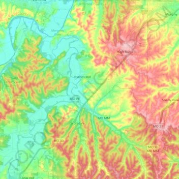
Name: High Ridge Township topographic map, elevation, terrain.

Location: High Ridge Township, Jefferson County, Missouri, 63049, United States (38.35229 -90.63189 38.50175 -90.51234)

Average elevation: 196 m

Minimum elevation: 123 m

Maximum elevation: 292 m

Other topographic maps

Click on a map to view its topography, its elevation and its terrain.

High Ridge

United States > Missouri > Jefferson County

Average elevation: 246 m

Local

United States > Missouri > Jefferson County

Average elevation: 176 m

Dittmer

United States > Missouri > Jefferson County

Average elevation: 193 m

Gear up for your next adventure:

🎒Fully Waterproof Backpack - Total protection for photography gear and electronics
🧰Survival Kit - Essential gear for emergencies in the wilderness
🧊Insulated Water Bottle - Keeps drinks cold in summer and prevents freezing in winter
🧼Biodegradable Camp Soap - Environmentally friendly cleaning for gear and body
🥾Hiking Gaiters - Protect legs and shoes from mud, snow, and debris

As an Amazon Associate, this site earns from qualifying purchases at no extra cost to you.