
Make a donation
Gear up for your next adventure:
As an Amazon Associate, this site earns from qualifying purchases at no extra cost to you.
Vera de Moncayo topographic map
Click on the map to display elevation.
Make a donation
Gear up for your next adventure:
As an Amazon Associate, this site earns from qualifying purchases at no extra cost to you.
Vera de Moncayo
Der Ort Vera de Moncayo liegt am Río Huecha zu Füßen der maximal ca. 2315 m hohen Sierra de Moncayo etwa 78 km (Fahrtstrecke) nordwestlich der Provinzhauptstadt Saragossa nahe der Grenze zur altkastilischen Provinz Soria in einer Höhe von ca. 630 m; die sehenswerte Kleinstadt Borja befindet sich ca. 14 km östlich. Das Klima ist gemäßigt bis warm; Regen (ca. 475 mm/Jahr) fällt mit Ausnahme der Sommermonate übers Jahr verteilt.
Make a donation
Gear up for your next adventure:
As an Amazon Associate, this site earns from qualifying purchases at no extra cost to you.
About this map
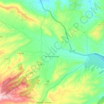
Name: Vera de Moncayo topographic map, elevation, terrain.
Average elevation: 688 m
Minimum elevation: 544 m
Maximum elevation: 954 m
Make a donation
Gear up for your next adventure:
As an Amazon Associate, this site earns from qualifying purchases at no extra cost to you.