
General Carrera Lake / Lake Buenos Aires topographic map
Interactive map
Click on the map to display elevation.
About this map
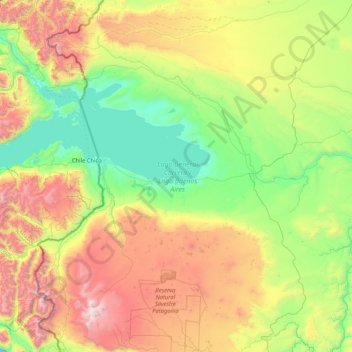
Name: General Carrera Lake / Lake Buenos Aires topographic map, elevation, terrain.
Average elevation: 893 m
Minimum elevation: 152 m
Maximum elevation: 2,694 m
The lake occupies a continental-scale graben formed by SWS-ENE normal faults that have resulted in down-dropping the bottom of the lake to 350 meters (1,150 ft) below mean sea level. Preservation of younger lithostratigraphic units within the graben form reverse stratigraphy with older units exposed at higher topographic elevations to the south. The graben channeled mountain glaciers which formed terminal moraine helping to modify the present-day shape of the lake. The tectonic activity that formed the depression can be inferred to subduction of the triple joint that has occurred over the past 20 million years, as indicated by ripple marks in volcaniclastic sediments observed along the southern shoreline. There is some speculation on whether the tectonics and crustal heat flow in the lake area are influenced by the asthenospheric window that exists beneath the crust in this region of Patagonia.
Other topographic maps
Click on a map to view its topography, its elevation and its terrain.
El Chaltén
Argentina > Santa Cruz Province
El Chaltén, Lago Argentino, Santa Cruz Province, Argentina
Average elevation: 524 m
El Calafate
Argentina > Santa Cruz Province > El Calafate
El Calafate, Lago Argentino, Santa Cruz Province, Argentina
Average elevation: 251 m
Magallanes
Argentina > Santa Cruz Province
Magallanes, Santa Cruz Province, Argentina
Average elevation: 244 m
Río Gallegos
Argentina > Santa Cruz Province > Río Gallegos
Río Gallegos, Güer Aike, Santa Cruz Province, Argentina
Average elevation: 9 m
Perito Moreno Glacier
Argentina > Santa Cruz Province
Perito Moreno Glacier, Lago Argentino, Santa Cruz Province, Argentina
Average elevation: 1,451 m
Perito Moreno
Argentina > Santa Cruz Province
Perito Moreno, Lago Buenos Aires, Santa Cruz Province, Argentina
Average elevation: 407 m