
Make a donation
Gear up for your next adventure:
As an Amazon Associate, this site earns from qualifying purchases at no extra cost to you.
Makouda topographic map
Click on the map to display elevation.
Make a donation
Gear up for your next adventure:
As an Amazon Associate, this site earns from qualifying purchases at no extra cost to you.
Makouda
Makouda est située dans une région montagneuse, faisant partie de la chaîne de la Kabylie maritime, composée d'une plaine étroite dans sa partie sud, et du versant sud de la chaîne maritime au nord. Le point culminant de cette chaine est le mont Tifilkout (« la crête », dite « Tabourth t-varnusth »), à 910 m d'altitude.
Make a donation
Gear up for your next adventure:
As an Amazon Associate, this site earns from qualifying purchases at no extra cost to you.
About this map
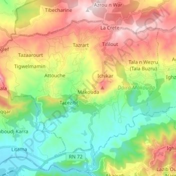
Name: Makouda topographic map, elevation, terrain.
Location: Makouda, Daïra de Makouda, Tizi Ouzou, Algérie (36.75588 3.98969 36.83205 4.11179)
Average elevation: 376 m
Minimum elevation: 39 m
Maximum elevation: 888 m
Make a donation
Gear up for your next adventure:
As an Amazon Associate, this site earns from qualifying purchases at no extra cost to you.
Other topographic maps
Click on a map to view its topography, its elevation and its terrain.