Geolocate

Ingolstadt topographic map

Click on the map to display elevation.

About this map

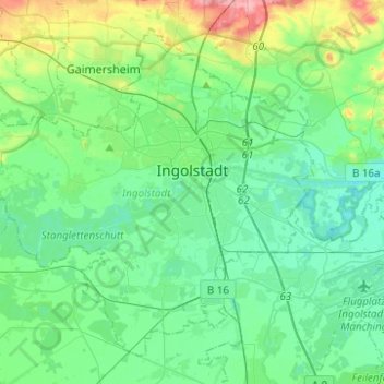
Name: Ingolstadt topographic map, elevation, terrain.

Location: Ingolstadt, Bavaria, Germany (48.68388 11.25591 48.82289 11.50342)

Average elevation: 378 m

Minimum elevation: 353 m

Maximum elevation: 464 m

Gear up for your next adventure:

🛌Down Sleeping Bag - Superior warmth-to-weight ratio for cold nights
💡LED Headlamp - Hands-free illumination for night hiking and camping
🪜Heavy Duty Carabiners - Multi-use clips for securing gear to your backpack
🚲Handlebar Phone Mount - View topographic-map.com live while cycling
🥾Trekking Poles - Adjustable trekking poles to reduce knee stress and improve stability

As an Amazon Associate, this site earns from qualifying purchases at no extra cost to you.