Geolocate

Kahlenberg topographic map

Click on the map to display elevation.

About this map

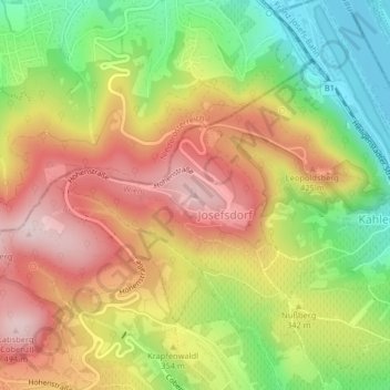
Name: Kahlenberg topographic map, elevation, terrain.

Location: Kahlenberg, Vienna, 3403, Austria (48.27629 16.33302 48.27639 16.33312)

Average elevation: 329 m

Minimum elevation: 157 m

Maximum elevation: 489 m

Other topographic maps

Click on a map to view its topography, its elevation and its terrain.

Meidling

Austria > Vienna

Average elevation: 208 m

Löwygrube

Austria > Vienna > Vienna

Average elevation: 208 m

Gear up for your next adventure:

🧣Evaporative Cooling Towel - Beat the heat during intense summer climbs
💧Reusable Water Bottle - Durable water bottles for hydration on trails
🧴First Aid Kit - Essential first aid supplies for outdoor emergencies
🧢Hiking Hat - Sun-protective and breathable hats for long treks
🪑Insulated Seat Pad - Protect your seat from cold rocks and wet logs

As an Amazon Associate, this site earns from qualifying purchases at no extra cost to you.