Geolocate

Clearwater topographic map

Click on the map to display elevation.

About this map

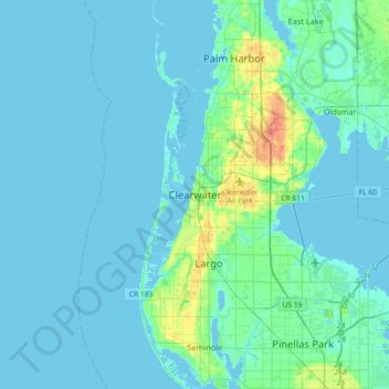
Name: Clearwater topographic map, elevation, terrain.

Location: Clearwater, Pinellas County, Florida, 33756, United States (27.80585 -82.96010 28.12585 -82.64010)

Average elevation: 4 m

Minimum elevation: -2 m

Maximum elevation: 35 m

Other topographic maps

Click on a map to view its topography, its elevation and its terrain.

Gear up for your next adventure:

💡LED Headlamp - Hands-free illumination for night hiking and camping
🧥Waterproof Jacket - Lightweight rain jackets for hiking and outdoor activities
🥾Waterproof Trail Shoes - Shoes designed to handle wet terrain
🥫Freeze-Dried Meals - Lightweight, high-calorie nutrition for multi-day treks
🧥Insulated Jacket - Keep warm in cold outdoor conditions

As an Amazon Associate, this site earns from qualifying purchases at no extra cost to you.