
Make a donation
Gear up for your next adventure:
As an Amazon Associate, this site earns from qualifying purchases at no extra cost to you.
Vidago topographic map
Click on the map to display elevation.
Make a donation
Gear up for your next adventure:
As an Amazon Associate, this site earns from qualifying purchases at no extra cost to you.
Vidago
Há quem diga que Vidago foi uma estância termal no tempo dos Romanos, que ali iam fazer as suas curas e tanto bebiam como lavavam os seus corpos nas santas águas, para curar os seus males. Sabe-se que o seu povoamento é muito anterior ao século XII, embora nessa altura não passasse de uma aldeia sem mais importância do que as circunvizinhas. É natural que o lugar já fosse povoado em épocas pré-romanas, como se deduz da arqueologia, da topografia e da própria toponímia locais, visto que não só a sua situação geográfica a tornava própria à defesa estratégica, como também a riqueza da região em águas minerais não seria desaproveitada pelos Romanos, que sempre usaram as nascentes termais, onde se encontravam.
Make a donation
Gear up for your next adventure:
As an Amazon Associate, this site earns from qualifying purchases at no extra cost to you.
About this map
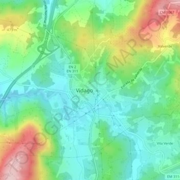
Name: Vidago topographic map, elevation, terrain.
Average elevation: 398 m
Minimum elevation: 321 m
Maximum elevation: 557 m
Make a donation
Gear up for your next adventure:
As an Amazon Associate, this site earns from qualifying purchases at no extra cost to you.