
Vallée de l'Ernz topographic map
Interactive map
Click on the map to display elevation.
About this map
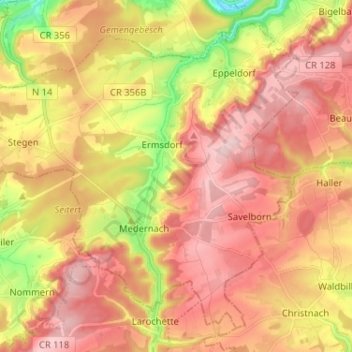
Name: Vallée de l'Ernz topographic map, elevation, terrain.
Location: Vallée de l'Ernz, Canton Diekirch, Luxembourg (49.78538 6.14267 49.85747 6.27146)
Average elevation: 330 m
Minimum elevation: 182 m
Maximum elevation: 432 m
Other topographic maps
Click on a map to view its topography, its elevation and its terrain.
Ettelbruck
Ettelbruck, Canton Diekirch, Luxembourg
Average elevation: 282 m
Ingeldorf
Ingeldorf, Erpeldange-sur-Sûre, Canton Diekirch, 9161, Luxembourg
Average elevation: 272 m
Wallendorf-Pont
Wallendorf-Pont, Reisdorf, Canton Diekirch, 9392, Luxembourg
Average elevation: 274 m
Warken
Luxembourg > Canton Diekirch > Ettelbruck
Warken, Ettelbruck, Canton Diekirch, 9018, Luxembourg
Average elevation: 275 m
Moulin de Bourscheid
Luxembourg > Canton Diekirch > Lipperscheid > Moulin de Bourscheid
Moulin de Bourscheid, Lipperscheid, Bourscheid, Canton Diekirch, 9164, Luxembourg
Average elevation: 373 m
Bleesbruck
Luxembourg > Canton Diekirch > Gilsdorf
Bleesbruck, Gilsdorf, Bettendorf, Canton Diekirch, 9359, Luxembourg
Average elevation: 271 m