
Thank you for supporting this site ❤️
Make a donation
Make a donation
Gear up for your next adventure:
As an Amazon Associate, this site earns from qualifying purchases at no extra cost to you.
Distrito A topographic map
Click on the map to display elevation.
Thank you for supporting this site ❤️
Make a donation
Make a donation
Gear up for your next adventure:
As an Amazon Associate, this site earns from qualifying purchases at no extra cost to you.
About this map
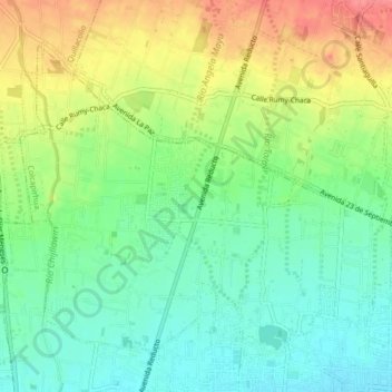
Name: Distrito A topographic map, elevation, terrain.
Location: Distrito A, Pocpocollo, Quillacollo, Cochabamba, Bolivia (-17.38209 -66.25247 -17.34990 -66.20998)
Average elevation: 2,579 m
Minimum elevation: 2,550 m
Maximum elevation: 2,622 m
Thank you for supporting this site ❤️
Make a donation
Make a donation
Gear up for your next adventure:
As an Amazon Associate, this site earns from qualifying purchases at no extra cost to you.