
Make a donation
Gear up for your next adventure:
As an Amazon Associate, this site earns from qualifying purchases at no extra cost to you.
Freilassing topographic map
Click on the map to display elevation.
Make a donation
Gear up for your next adventure:
As an Amazon Associate, this site earns from qualifying purchases at no extra cost to you.
About this map
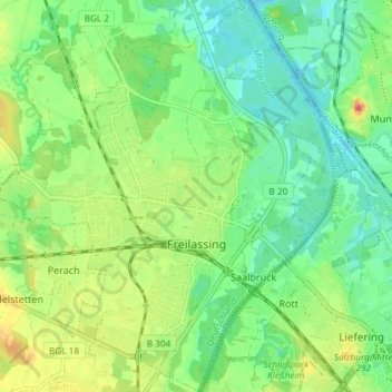
Name: Freilassing topographic map, elevation, terrain.
Average elevation: 418 m
Minimum elevation: 398 m
Maximum elevation: 452 m
Make a donation
Gear up for your next adventure:
As an Amazon Associate, this site earns from qualifying purchases at no extra cost to you.
Other topographic maps
Click on a map to view its topography, its elevation and its terrain.
Kehlstein
Duitsland > Beieren > Landkreis Berchtesgadener Land > Berchtesgaden
Average elevation: 1,417 m
Weißbach an der Alpenstraße
Duitsland > Beieren > Landkreis Berchtesgadener Land > Weißbach an der Alpenstraße
Average elevation: 839 m
Hoher Göll
Duitsland > Beieren > Landkreis Berchtesgadener Land > Schönau am Königssee
Average elevation: 1,904 m
Kehlstein
Duitsland > Beieren > Landkreis Berchtesgadener Land > Berchtesgaden
Average elevation: 1,417 m
Make a donation
Gear up for your next adventure:
As an Amazon Associate, this site earns from qualifying purchases at no extra cost to you.