Geolocate

Alliance topographic map

Click on the map to display elevation.

About this map

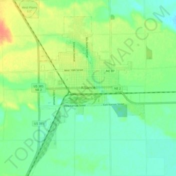
Name: Alliance topographic map, elevation, terrain.

Location: Alliance, Box Butte County, Nebraska, 69301, United States (42.06051 -102.91176 42.13345 -102.83928)

Average elevation: 1,208 m

Minimum elevation: 1,192 m

Maximum elevation: 1,235 m

Gear up for your next adventure:

🧭GPS Tracker - Track your location in remote areas safely
🥾Hiking Leggings - Comfortable leggings for outdoor activities
🥾Lightweight Hiking Boots - Boots for comfort and mobility on long hikes
🦯Trekking Poles - Reduced impact on joints for steep topographic climbs
🍽️Titanium Camping Spork - Ultralight and indestructible eating utensil

As an Amazon Associate, this site earns from qualifying purchases at no extra cost to you.