
Make a donation
Gear up for your next adventure:
As an Amazon Associate, this site earns from qualifying purchases at no extra cost to you.
Coralville topographic map
Click on the map to display elevation.
Make a donation
Gear up for your next adventure:
As an Amazon Associate, this site earns from qualifying purchases at no extra cost to you.
About this map
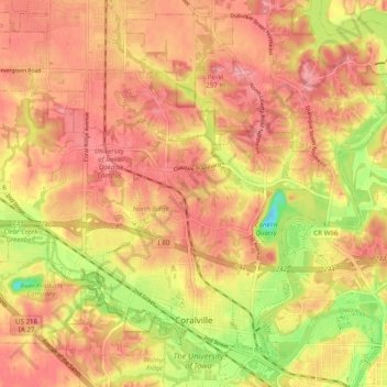
Name: Coralville topographic map, elevation, terrain.
Location: Coralville, Johnson County, Iowa, 52241, United States (41.66628 -91.64696 41.73358 -91.54908)
Average elevation: 224 m
Minimum elevation: 162 m
Maximum elevation: 255 m
Make a donation
Gear up for your next adventure:
As an Amazon Associate, this site earns from qualifying purchases at no extra cost to you.
Other topographic maps
Click on a map to view its topography, its elevation and its terrain.
Iowa City
United States > Iowa > Johnson County > Iowa City
The elevation at the Iowa City Municipal Airport is 668 ft (203.6 m) above sea level.
Average elevation: 225 m