Geolocate

Valeene topographic map

Click on the map to display elevation.

About this map

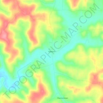
Name: Valeene topographic map, elevation, terrain.

Location: Valeene, Orange County, Indiana, United States (38.41895 -86.41721 38.45895 -86.37721)

Average elevation: 217 m

Minimum elevation: 174 m

Maximum elevation: 269 m

Other topographic maps

Click on a map to view its topography, its elevation and its terrain.

Orleans

United States > Indiana > Orange County

Average elevation: 199 m

Gear up for your next adventure:

Camping Tent - Weather-resistant tents suitable for 2 to 6 people
🛰️Satellite Messenger - Emergency communication for areas with no cell service
🔋Lithium AA Batteries - Long-lasting power that performs in extreme cold
🧭GPS Outdoor Watch - Smart watch for navigation and fitness tracking in nature
🎒Backpack Rain Cover - External shield to keep your entire pack dry

As an Amazon Associate, this site earns from qualifying purchases at no extra cost to you.