Geolocate

Hanover Township topographic map

Click on the map to display elevation.

About this map

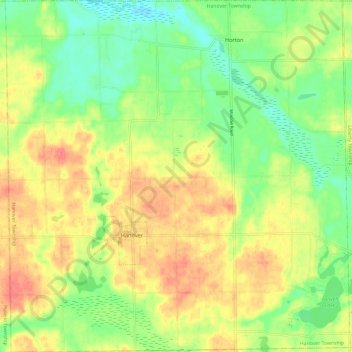
Name: Hanover Township topographic map, elevation, terrain.

Location: Hanover Township, Jackson County, Michigan, United States (42.07173 -84.59490 42.16026 -84.47784)

Average elevation: 328 m

Minimum elevation: 299 m

Maximum elevation: 359 m

Other topographic maps

Click on a map to view its topography, its elevation and its terrain.

Skiff Lake

United States > Michigan > Jackson County

Average elevation: 308 m

Honey Lake

United States > Michigan > Jackson County

Average elevation: 304 m

Olcott Lake

United States > Michigan > Jackson County

Average elevation: 289 m

Horton

United States > Michigan > Jackson County

Average elevation: 318 m

Leoni

United States > Michigan > Jackson County

Average elevation: 301 m

White Lake

United States > Michigan > Jackson County

Average elevation: 288 m

Gear up for your next adventure:

🧴Waterproofing Spray - Restore the DWR coating on jackets and tents
🔨Vehicle Emergency Tool - Safety tool for remote road trips to trailheads
Family Camping Tent - Spacious tent suitable for family camping trips
🥤Collapsible Travel Cup - Saves space and weight in your mess kit
Backpacking Tent - Lightweight tent for long-distance hiking trips

As an Amazon Associate, this site earns from qualifying purchases at no extra cost to you.