
Make a donation
Gear up for your next adventure:
As an Amazon Associate, this site earns from qualifying purchases at no extra cost to you.
Combleval topographic map
Click on the map to display elevation.
Make a donation
Gear up for your next adventure:
As an Amazon Associate, this site earns from qualifying purchases at no extra cost to you.
About this map
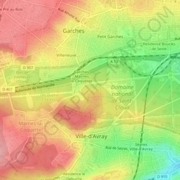
Name: Combleval topographic map, elevation, terrain.
Average elevation: 126 m
Minimum elevation: 54 m
Maximum elevation: 177 m
Make a donation
Gear up for your next adventure:
As an Amazon Associate, this site earns from qualifying purchases at no extra cost to you.
Other topographic maps
Click on a map to view its topography, its elevation and its terrain.
Domaine national de Saint-Cloud
France > Île-de-France > Hauts-de-Seine > Saint-Cloud
Louis-Philippe-Joseph, successeur de Louis-Philippe le Gros, surnommé plus tard Philippe-Égalité par la Convention durant la Révolution, a marqué le domaine par son expérience de vol aérostatique. En effet, il organise le 15 juillet 1784 un vol expérimental à bord d'un aérostat depuis le parterre des…
Average elevation: 132 m