
Make a donation
Gear up for your next adventure:
As an Amazon Associate, this site earns from qualifying purchases at no extra cost to you.
Grub topographic map
Click on the map to display elevation.
Make a donation
Gear up for your next adventure:
As an Amazon Associate, this site earns from qualifying purchases at no extra cost to you.
About this map
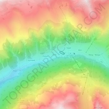
Name: Grub topographic map, elevation, terrain.
Location: Grub, Graun, Vinschgau, Bozen, Trentino-Südtirol, Italien (46.81723 10.61389 46.85723 10.65389)
Average elevation: 2,262 m
Minimum elevation: 1,740 m
Maximum elevation: 2,800 m
Make a donation
Gear up for your next adventure:
As an Amazon Associate, this site earns from qualifying purchases at no extra cost to you.
Other topographic maps
Click on a map to view its topography, its elevation and its terrain.
Reschensee
Italien > Trentino-Südtirol > Bozen > Graun > Froi
Im Reschensee wird das Wasser der Etsch, des Rojenbachs, des Karlinbachs und einiger kleinerer Zuflüsse gestaut. Der künstliche See hat mit sechs Kilometer Länge und an der breitesten Stelle etwa einem Kilometer Breite ein Stauvolumen von 120 Mio. m³, das fast vollständig als Speichervolumen genutzt wird…
Average elevation: 1,871 m