
Supai topographic map
Click on the map to display elevation.
Supai
Supai can be reached by hiking 8 miles (13 km), descending 2,004 feet (611 m) in elevation from Hualapai Hilltop through the Hualapai Canyon. Alternatively, the AirWest Helicopters service schedules flights from Hualapai Hilltop to Supai. Hualapai Hilltop is located about 70 miles (110 km) from the community of Peach Springs, along paved BIA Road 18.
About this map
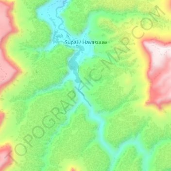
Name: Supai topographic map, elevation, terrain.
Location: Supai, Coconino County, Arizona, United States (36.19783 -112.70754 36.24934 -112.67665)
Average elevation: 1,263 m
Minimum elevation: 927 m
Maximum elevation: 1,806 m