Geolocate

Stanley topographic map

Click on the map to display elevation.

About this map

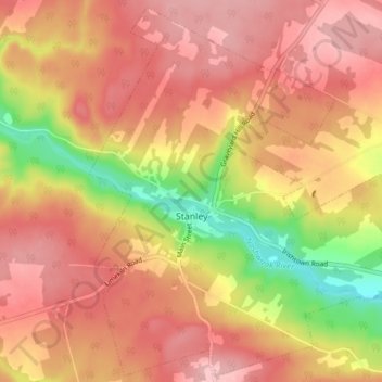
Name: Stanley topographic map, elevation, terrain.

Location: Stanley, Stanley Parish, New Brunswick, Canada (46.26081 -66.76178 46.31208 -66.68507)

Average elevation: 175 m

Minimum elevation: 69 m

Maximum elevation: 235 m

Stanley Parish trails, hiking, mountain biking, running and outdoor activities

Other topographic maps

Click on a map to view its topography, its elevation and its terrain.

Williamsburg

Canada > New Brunswick > Stanley Parish

Average elevation: 246 m

Gear up for your next adventure:

🧥Waterproof Pants - Keep dry during rainy hiking conditions
🥾Trail Hiking Socks - Comfortable socks to prevent blisters and fatigue
🏃Hydration Running Vest - Carry water and maps close to your body for speed
📷Outdoor Action Camera - Capture high-elevation views and rugged adventures
💡Portable Camping Lamp - Rechargeable lamp for campsite lighting

As an Amazon Associate, this site earns from qualifying purchases at no extra cost to you.