
Make a donation
Gear up for your next adventure:
As an Amazon Associate, this site earns from qualifying purchases at no extra cost to you.
Ussel topographic map
Click on the map to display elevation.
Make a donation
Gear up for your next adventure:
As an Amazon Associate, this site earns from qualifying purchases at no extra cost to you.
Ussel
The community of Ussel is located in the Massif central on the foothills of the plateau de Millevaches. The city itself sits on a hilltop in between the valley of the river Diège and the valley of the river Sarsonne. It is situated at an altitude of 2070 ft (631 m), in the Massif Central on the last buttress of the Plateau de Millevaches. Ussel is crossed by the Green Meridian.
Make a donation
Gear up for your next adventure:
As an Amazon Associate, this site earns from qualifying purchases at no extra cost to you.
About this map
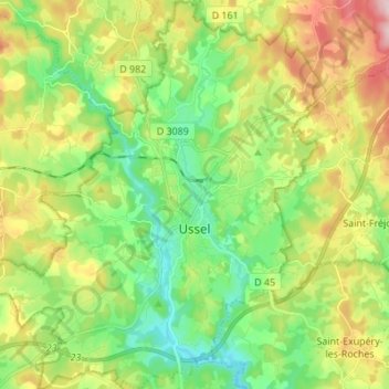
Name: Ussel topographic map, elevation, terrain.
Average elevation: 680 m
Minimum elevation: 582 m
Maximum elevation: 845 m
Make a donation
Gear up for your next adventure:
As an Amazon Associate, this site earns from qualifying purchases at no extra cost to you.
Other topographic maps
Click on a map to view its topography, its elevation and its terrain.
Make a donation
Gear up for your next adventure:
As an Amazon Associate, this site earns from qualifying purchases at no extra cost to you.