Geolocate

Bad Liebenstein topographic map

Click on the map to display elevation.

About this map

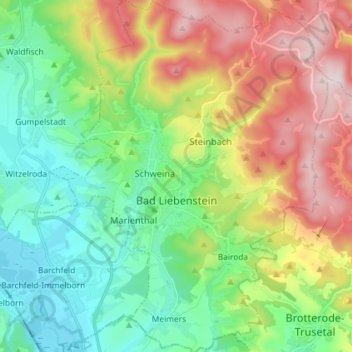
Name: Bad Liebenstein topographic map, elevation, terrain.

Location: Bad Liebenstein, Wartburgkreis, Thuringia, Germany (50.77870 10.29678 50.87039 10.41205)

Average elevation: 424 m

Minimum elevation: 239 m

Maximum elevation: 748 m

Other topographic maps

Click on a map to view its topography, its elevation and its terrain.

Reichenbach

Germany > Thuringia > Wartburgkreis

Average elevation: 333 m

Ramsberg

Germany > Thuringia > Wartburgkreis > Lauterbach

Average elevation: 324 m

Buchenau

Germany > Thuringia > Wartburgkreis

Average elevation: 284 m

Lauchröden

Germany > Thuringia > Wartburgkreis

Average elevation: 242 m

Wartburg

Germany > Thuringia > Wartburgkreis > Eisenach

Average elevation: 284 m

Hütscheroda

Germany > Thuringia > Wartburgkreis

Average elevation: 356 m

Walkes

Germany > Thuringia > Wartburgkreis > Geisa

Average elevation: 487 m

Gear up for your next adventure:

🦯Trekking Poles - Reduced impact on joints for steep topographic climbs
🧤Rechargeable Heated Gloves - Extreme warmth for Canadian winter expeditions
🧢Sun Hat - Wide-brim hat for sun protection
🛰️Satellite Messenger - Emergency communication for areas with no cell service
💧Filtered Water Bottle - Safe drinking water on the go

As an Amazon Associate, this site earns from qualifying purchases at no extra cost to you.