Geolocate

l'Éperon topographic map

Click on the map to display elevation.

About this map

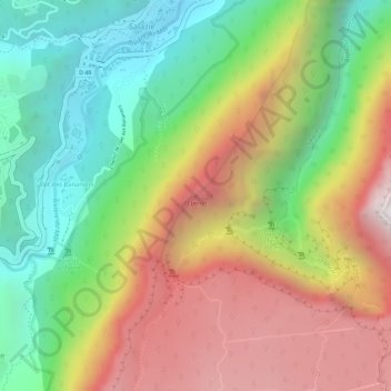
Name: l'Éperon topographic map, elevation, terrain.

Location: l'Éperon, Salazie, Saint-Benoît, La Réunion, 97433, France (-21.03615 55.54748 -21.03605 55.54758)

Average elevation: 937 m

Minimum elevation: 388 m

Maximum elevation: 1,547 m

Gear up for your next adventure:

🧦Hiking Socks - Moisture-wicking and comfortable socks for long hikes
🧊Insulated Water Bottle - Keeps drinks cold in summer and prevents freezing in winter
🥤Collapsible Travel Cup - Saves space and weight in your mess kit
🧭Orienteering Kit - Tools for map reading and navigation in the wild
🥾Hiking Leggings - Comfortable leggings for outdoor activities

As an Amazon Associate, this site earns from qualifying purchases at no extra cost to you.