Geolocate

Lambzig topographic map

Click on the map to display elevation.

Lambzig

Lambzig liegt im Osten des Gebiets der Stadt Netzschkau. Der Ort befindet sich im Osten des Naturraumes Vogtland im sächsischen Teil des historischen Vogtlands. Lambzig liegt auf einem Höhenrücken, der im Westen vom Limbach und im Osten von der Göltzsch begrenzt wird.

Wikipedia (CC-BY-SA 3.0)

About this map

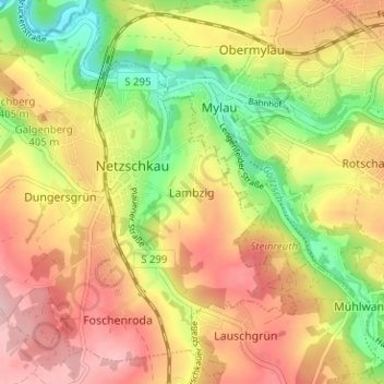
Name: Lambzig topographic map, elevation, terrain.

Location: Lambzig, Netzschkau, Netzschkau-Limbach, Vogtlandkreis, Sachsen, 08491, Deutschland (50.59054 12.23845 50.63054 12.27845)

Average elevation: 377 m

Minimum elevation: 279 m

Maximum elevation: 462 m

Other topographic maps

Click on a map to view its topography, its elevation and its terrain.

Limbach

Deutschland > Sachsen > Vogtlandkreis > Netzschkau > Lambzig

Average elevation: 349 m

Gear up for your next adventure:

🛌Down Sleeping Bag - Superior warmth-to-weight ratio for cold nights
🥾Waterproof Hiking Boots - Essential footwear for rugged terrain and wet Canadian trails
🥾Lightweight Hiking Shoes - Comfortable shoes for day hikes
🪑Ultralight Camping Stool - Compact seating for rest stops during long hikes
🥾Approach Shoes - Shoes designed for climbing approaches and rugged trails

As an Amazon Associate, this site earns from qualifying purchases at no extra cost to you.