Geolocate

Pacheco topographic map

Click on the map to display elevation.

About this map

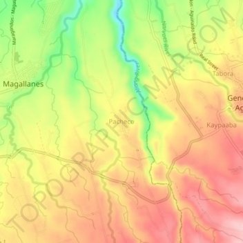
Name: Pacheco topographic map, elevation, terrain.

Location: Pacheco, Magallanes, Cavite, Calabarzon, 4113, Philippines (14.16122 120.75403 14.20122 120.79403)

Average elevation: 183 m

Minimum elevation: 85 m

Maximum elevation: 251 m

Other topographic maps

Click on a map to view its topography, its elevation and its terrain.

Buhay Forest

Philippines > Cavite > Magallanes > Ramirez

Average elevation: 192 m

Gear up for your next adventure:

🚲Heavy Duty Bike Lock - Secure your bike at the trailhead or during stops
🕶️Polarized Sunglasses - Reduces glare from snow and water at high elevations
🧥Fleece Jacket - Warm and lightweight jacket for layering
🕶️Polarized Sunglasses - Protect your eyes with durable polarized lenses
🛶Kayak Dry Bag - Waterproof storage for kayaking adventures

As an Amazon Associate, this site earns from qualifying purchases at no extra cost to you.