Geolocate

Scicli topographic map

Click on the map to display elevation.

About this map

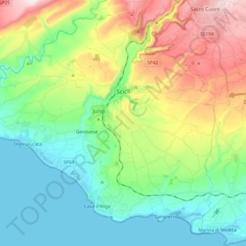
Name: Scicli topographic map, elevation, terrain.

Location: Scicli, Ragusa, Sicily, 97018, Italy (36.71005 14.59446 36.83963 14.77384)

Average elevation: 155 m

Minimum elevation: 0 m

Maximum elevation: 477 m

Gear up for your next adventure:

🛶Canoe Life Vest - Safety vest for water sports
🧰Multitool Knife - Compact and versatile tool for outdoor use
🦶Hiking Shoe Insoles - Added support for high arches and long days on feet
🛏️Sleeping Bag - Warm and compact sleeping bags for outdoor camping
🥾Lightweight Hiking Boots - Boots for comfort and mobility on long hikes

As an Amazon Associate, this site earns from qualifying purchases at no extra cost to you.