
Thank you for supporting this site ❤️
Make a donation
Make a donation
Gear up for your next adventure:
As an Amazon Associate, this site earns from qualifying purchases at no extra cost to you.
Tafawa-Balewa topographic map
Click on the map to display elevation.
Thank you for supporting this site ❤️
Make a donation
Make a donation
Gear up for your next adventure:
As an Amazon Associate, this site earns from qualifying purchases at no extra cost to you.
About this map
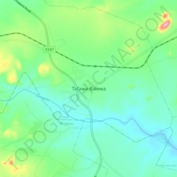
Name: Tafawa-Balewa topographic map, elevation, terrain.
Location: Tafawa-Balewa, Wai B, Tafawa-Balewa, Bauchi State, Nigeria (9.72052 9.51354 9.80052 9.59354)
Average elevation: 654 m
Minimum elevation: 605 m
Maximum elevation: 806 m
Thank you for supporting this site ❤️
Make a donation
Make a donation
Gear up for your next adventure:
As an Amazon Associate, this site earns from qualifying purchases at no extra cost to you.