Geolocate

84307 topographic map

Click on the map to display elevation.

About this map

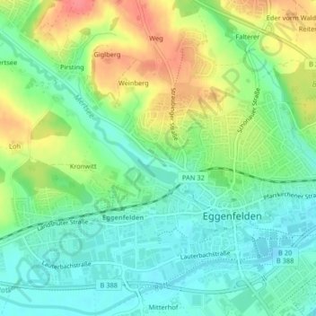
Name: 84307 topographic map, elevation, terrain.

Location: 84307, Eggenfelden, Landkreis Rottal-Inn, Bayern, Deutschland (48.40808 12.75301 48.40818 12.75311)

Average elevation: 425 m

Minimum elevation: 399 m

Maximum elevation: 468 m

Other topographic maps

Click on a map to view its topography, its elevation and its terrain.

Gear up for your next adventure:

🥾Mountain Hiking Shoes - Shoes with superior grip for mountainous terrain
🏕️Camping Hammock - Integrated protection for sleeping between trees
🏃Hydration Running Vest - Carry water and maps close to your body for speed
🧴Insect Repellent - Protect yourself from bugs during outdoor adventures
🥾Trail Running Shoes - Lightweight and durable shoes for trail running

As an Amazon Associate, this site earns from qualifying purchases at no extra cost to you.