Geolocate

Leimán topographic map

Click on the map to display elevation.

About this map

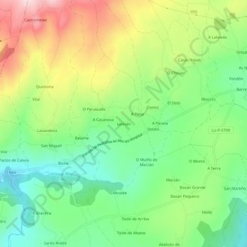
Name: Leimán topographic map, elevation, terrain.

Location: Leimán, Belante, Sarria, Lugo, Galicia, 27612, España (42.75837 -7.50660 42.79837 -7.46660)

Average elevation: 635 m

Minimum elevation: 519 m

Maximum elevation: 810 m

Other topographic maps

Click on a map to view its topography, its elevation and its terrain.

Chorente

España > Galicia > Sarria > Sarria

Average elevation: 626 m

Barbadelo

España > Galicia > Sarria > Sarria

Average elevation: 576 m

Ortoá

España > Galicia > Sarria > Sarria

Average elevation: 614 m

Louseiro

España > Galicia > Sarria > Sarria

Average elevation: 507 m

Vilamaior

España > Galicia > Sarria > Sarria

Average elevation: 623 m

Santo André de Paradela

España > Galicia > Sarria > Sarria

Average elevation: 578 m

Fontao

España > Galicia > Sarria > Sarria

Average elevation: 460 m

Gear up for your next adventure:

Lightweight Backpacking Tent - Compact tent for efficient hiking trips
🧭GPS Outdoor Watch - Smart watch for navigation and fitness tracking in nature
👟Trail Running Shoes - Agile footwear for fast-paced topographic exploration
🧴Insect Repellent - Protect yourself from bugs during outdoor adventures
💧Hydration Bladder - Hands-free hydration solution for long treks

As an Amazon Associate, this site earns from qualifying purchases at no extra cost to you.