
Make a donation
Gear up for your next adventure:
As an Amazon Associate, this site earns from qualifying purchases at no extra cost to you.
Lhünzhub County topographic map
Click on the map to display elevation.
Make a donation
Gear up for your next adventure:
As an Amazon Associate, this site earns from qualifying purchases at no extra cost to you.
Lhünzhub County
Lhünzhub County is situated in central Tibet, approximately 65 km (40 mi) northeast of Lhasa. The county encompasses the Pengbo River Valley and the upper reaches of the Lhasa River, covering an area of 4,512 km2 (1,742 sq mi). The region is geologically diverse, with an average elevation of 4,000 metres (13,000 ft). Lhünzhub County is rich in mineral resources, including lead, zinc, copper, silver, gold, and gypsum. The Nyainqêntanglha Mountains extend through the county, dividing it into southern and northern regions.
Make a donation
Gear up for your next adventure:
As an Amazon Associate, this site earns from qualifying purchases at no extra cost to you.
About this map
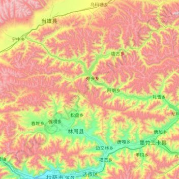
Name: Lhünzhub County topographic map, elevation, terrain.
Location: Lhünzhub County, Lhasa, Tibet, China (29.75339 90.84262 30.46717 91.92735)
Average elevation: 4,634 m
Minimum elevation: 3,638 m
Maximum elevation: 6,055 m
Make a donation
Gear up for your next adventure:
As an Amazon Associate, this site earns from qualifying purchases at no extra cost to you.
Other topographic maps
Click on a map to view its topography, its elevation and its terrain.
Yangbajain
The Yangbajain hot springs field is at an elevation of 4,290 to 4,500 metres (14,070 to 14,760 ft) which makes it the highest elevation set of hot springs in China, and possibly the world. The highest temperature inside the drilling hole is 125.5°C.
Average elevation: 4,448 m