
Make a donation
Gear up for your next adventure:
As an Amazon Associate, this site earns from qualifying purchases at no extra cost to you.
Municipio de Tijuana topographic map
Click on the map to display elevation.
Make a donation
Gear up for your next adventure:
As an Amazon Associate, this site earns from qualifying purchases at no extra cost to you.
About this map
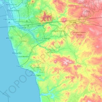
Name: Municipio de Tijuana topographic map, elevation, terrain.
Location: Municipio de Tijuana, Baja California, Mexico (32.18522 -117.30054 32.57108 -116.52399)
Average elevation: 369 m
Minimum elevation: -2 m
Maximum elevation: 1,330 m
Make a donation
Gear up for your next adventure:
As an Amazon Associate, this site earns from qualifying purchases at no extra cost to you.
Other topographic maps
Click on a map to view its topography, its elevation and its terrain.
Hacienda Casa Grande
Mexico > Baja California > Municipio de Tijuana > Hacienda Casa Grande
Average elevation: 170 m
Make a donation
Gear up for your next adventure:
As an Amazon Associate, this site earns from qualifying purchases at no extra cost to you.
Lomas del Valle
Mexico > Baja California > Municipio de Tijuana > Lomas del Valle
Average elevation: 220 m