Geolocate

Soquel topographic map

Click on the map to display elevation.

About this map

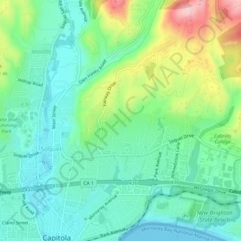
Name: Soquel topographic map, elevation, terrain.

Location: Soquel, Santa Cruz County, California, United States (36.98272 -121.97129 37.00240 -121.92926)

Average elevation: 60 m

Minimum elevation: 0 m

Maximum elevation: 203 m

Other topographic maps

Click on a map to view its topography, its elevation and its terrain.

Soquel

United States > California > Santa Cruz County > Soquel

Average elevation: 60 m

Gear up for your next adventure:

Backpacking Tent - Lightweight tent for long-distance hiking trips
Camping Tent - Weather-resistant tents suitable for 2 to 6 people
🧭GPS Handheld Device - Reliable GPS navigation for outdoor adventures
🧢Hiking Hat - Sun-protective and breathable hats for long treks
🧥Waterproof Hiking Jacket - Protect yourself from rain and wind while hiking

As an Amazon Associate, this site earns from qualifying purchases at no extra cost to you.