
Make a donation
Gear up for your next adventure:
As an Amazon Associate, this site earns from qualifying purchases at no extra cost to you.
Plats topographic map
Click on the map to display elevation.
Make a donation
Gear up for your next adventure:
As an Amazon Associate, this site earns from qualifying purchases at no extra cost to you.
About this map
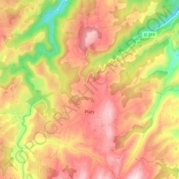
Name: Plats topographic map, elevation, terrain.
Average elevation: 394 m
Minimum elevation: 159 m
Maximum elevation: 567 m
Make a donation
Gear up for your next adventure:
As an Amazon Associate, this site earns from qualifying purchases at no extra cost to you.
Other topographic maps
Click on a map to view its topography, its elevation and its terrain.
Prends-Toi Garde
Frankrijk > Auvergne-Rhône-Alpes > Ardèche > Laurac-en-Vivarais
Average elevation: 206 m
Make a donation
Gear up for your next adventure:
As an Amazon Associate, this site earns from qualifying purchases at no extra cost to you.
Lac Ferrand
Frankrijk > Auvergne-Rhône-Alpes > Ardèche > Montpezat-sous-Bauzon
Average elevation: 1,251 m
Make a donation
Gear up for your next adventure:
As an Amazon Associate, this site earns from qualifying purchases at no extra cost to you.
Le Pommier
Frankrijk > Auvergne-Rhône-Alpes > Ardèche > Saint-Étienne-de-Lugdarès
Average elevation: 1,120 m
Make a donation
Gear up for your next adventure:
As an Amazon Associate, this site earns from qualifying purchases at no extra cost to you.
Make a donation
Gear up for your next adventure:
As an Amazon Associate, this site earns from qualifying purchases at no extra cost to you.