
Taunton topographic map
Click on the map to display elevation.
Taunton
Taunton has one major river, the Taunton River, along with its tributaries including the Mill River and the Three Mile River. The highest point in the city is near its southwest corner, with an elevation of 207 feet (63 m) above sea level. Prospect Hill, rising over Lake Sabbatia north of the downtown, has an elevation of 197 feet (60 m).
About this map
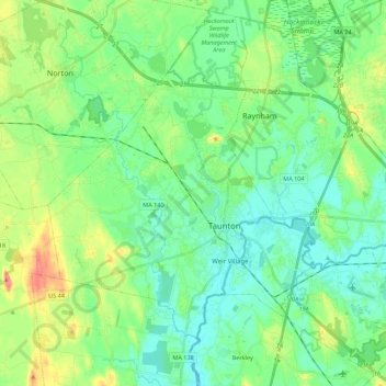
Name: Taunton topographic map, elevation, terrain.
Location: Taunton, Bristol County, Massachusetts, United States (41.83849 -71.19390 41.99318 -70.97372)
Average elevation: 22 m
Minimum elevation: 0 m
Maximum elevation: 78 m
Other topographic maps
Click on a map to view its topography, its elevation and its terrain.