Geolocate

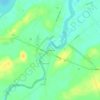
Akwesasne topographic map

Click on the map to display elevation.

About this map

Name: Akwesasne topographic map, elevation, terrain.

Location: Akwesasne, Town of Bombay, Franklin County, New York, United States (44.95236 -74.76059 45.07819 -74.44470)

Average elevation: 57 m

Minimum elevation: 35 m

Maximum elevation: 88 m

Other topographic maps

Click on a map to view its topography, its elevation and its terrain.
Gear up for your next adventure:

🔭Outdoor Binoculars - Lightweight binoculars for birdwatching and hiking
🛶Canoe Life Vest - Safety vest for water sports
🎒Fully Waterproof Backpack - Total protection for photography gear and electronics
🎒Backpack Rain Cover - External shield to keep your entire pack dry
🥾Mountaineering Boots - Supportive boots for climbing and high-altitude hiking

As an Amazon Associate, this site earns from qualifying purchases at no extra cost to you.