Geolocate

Clear Lake topographic map

Click on the map to display elevation.

About this map

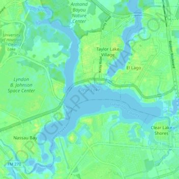
Name: Clear Lake topographic map, elevation, terrain.

Location: Clear Lake, Kemah, Galveston County, Texas, United States (29.52911 -95.09136 29.59633 -95.01761)

Average elevation: 5 m

Minimum elevation: -4 m

Maximum elevation: 12 m

Gear up for your next adventure:

🧦Hiking Liner Socks - Thin base layer to prevent friction and blisters
👟Sport Hiking Sandals - Breathable footwear for water crossings and camp rest
🛌Down Sleeping Bag - Superior warmth-to-weight ratio for cold nights
🧦Crew Hiking Socks - Comfortable socks for long-distance hikes
🔋Emergency Crank Radio - Weather alerts and power without needing batteries

As an Amazon Associate, this site earns from qualifying purchases at no extra cost to you.