Geolocate

Pangantucan topographic map

Click on the map to display elevation.

About this map

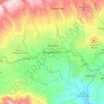
Name: Pangantucan topographic map, elevation, terrain.

Location: Pangantucan, Bukidnon, Northern Mindanao, 8717, Philippines (7.79003 124.78556 7.87003 124.86556)

Average elevation: 780 m

Minimum elevation: 508 m

Maximum elevation: 1,165 m

Other topographic maps

Click on a map to view its topography, its elevation and its terrain.

Lake Napalit

Philippines > Bukidnon > Pangantucan > Pigtauranan

Average elevation: 1,092 m

Maradugao River

Philippines > Bukidnon > Pangantucan

Average elevation: 336 m

Gear up for your next adventure:

🧦Crew Hiking Socks - Comfortable socks for long-distance hikes
👟Sport Hiking Sandals - Breathable footwear for water crossings and camp rest
🔭Compact Binoculars - Lightweight optics for scouting trails and wildlife
Bushcraft Tarp - Versatile emergency shelter or gear protection
🥾Waterproof Hiking Shoes - Durable shoes for wet and rugged trails

As an Amazon Associate, this site earns from qualifying purchases at no extra cost to you.