
Make a donation
Gear up for your next adventure:
As an Amazon Associate, this site earns from qualifying purchases at no extra cost to you.
Laguna Verde topographic map
Click on the map to display elevation.
Make a donation
Gear up for your next adventure:
As an Amazon Associate, this site earns from qualifying purchases at no extra cost to you.
About this map
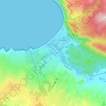
Name: Laguna Verde topographic map, elevation, terrain.
Average elevation: 107 m
Minimum elevation: 0 m
Maximum elevation: 380 m
Make a donation
Gear up for your next adventure:
As an Amazon Associate, this site earns from qualifying purchases at no extra cost to you.
Other topographic maps
Click on a map to view its topography, its elevation and its terrain.
Placilla de Peñuelas
Chile > Región de Valparaíso > Provincia de Valparaíso > Valparaíso
Average elevation: 354 m
Parque Quebrada Verde
Chile > Región de Valparaíso > Provincia de Valparaíso > Valparaíso > Quebrada Verde
Average elevation: 200 m
Plaza Waddington
Chile > Región de Valparaíso > Provincia de Valparaíso > Valparaíso
Average elevation: 50 m
Plaza Bismarck
Chile > Región de Valparaíso > Provincia de Valparaíso > Valparaíso
Average elevation: 153 m
Make a donation
Gear up for your next adventure:
As an Amazon Associate, this site earns from qualifying purchases at no extra cost to you.
Santuario de La Naturaleza Acantilados Federico Santa María
Chile > Región de Valparaíso > Provincia de Valparaíso > Valparaíso
Average elevation: 128 m
Isla San Félix
Chile > Región de Valparaíso > Provincia de Valparaíso > Valparaíso > Isla San Félix
Adyacente a la costa sureste de la isla se encuentra el Islote González. El islote Catedral es una mole rocosa de 53 m ubicada al noroeste de la isla. 19 km la separan de la vecina Isla de San Ambrosio, junto con la cual eran conocidas antiguamente como Islas Desventuradas. Su topografía es relativamente…
Average elevation: 10 m
Islas Desventuradas
Chile > Región de Valparaíso > Provincia de Valparaíso > Valparaíso
Average elevation: 1 m
Reserva Nacional Lago Peñuelas
Chile > Región de Valparaíso > Provincia de Valparaíso > Valparaíso
Average elevation: 369 m
Make a donation
Gear up for your next adventure:
As an Amazon Associate, this site earns from qualifying purchases at no extra cost to you.
Playa Las Torpederas
Chile > Región de Valparaíso > Provincia de Valparaíso > Valparaíso
Average elevation: 34 m