Geolocate

Bulimba topographic map

Click on the map to display elevation.

About this map

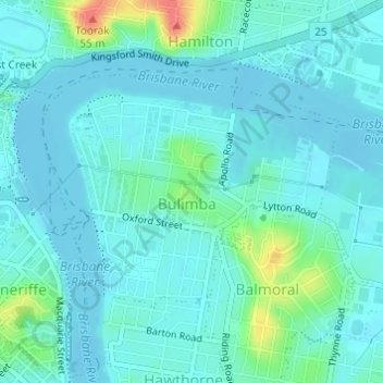
Name: Bulimba topographic map, elevation, terrain.

Location: Bulimba, City of Brisbane, Queensland, Australia (-27.45726 153.04854 -27.44074 153.07208)

Average elevation: 11 m

Minimum elevation: -3 m

Maximum elevation: 59 m

Other topographic maps

Click on a map to view its topography, its elevation and its terrain.

Bulimba Creek

Australia > Queensland > City of Brisbane

Average elevation: 11 m

Tangalooma

Australia > Queensland > City of Brisbane

Average elevation: 41 m

Enoggera Hill

Australia > Queensland > City of Brisbane

Average elevation: 114 m

Enoggera Dam

Australia > Queensland > City of Brisbane

Average elevation: 90 m

Blunder Creek

Australia > Queensland > City of Brisbane

Average elevation: 26 m

Tangalooma

Australia > Queensland > City of Brisbane

Average elevation: 41 m

Gear up for your next adventure:

💧Collapsible Water Bottle - Space-saving water bottle for outdoor activities
🧥Insulated Jacket - Keep warm in cold outdoor conditions
💧Reusable Water Bottle - Durable water bottles for hydration on trails
🛁Quick-Dry Microfiber Towel - Space-saving towel that dries rapidly on the move
🚑Survival Whistle - Signal for help across long distances in mountains

As an Amazon Associate, this site earns from qualifying purchases at no extra cost to you.