
Make a donation
Gear up for your next adventure:
As an Amazon Associate, this site earns from qualifying purchases at no extra cost to you.
Castelluccio topographic map
Click on the map to display elevation.
Make a donation
Gear up for your next adventure:
As an Amazon Associate, this site earns from qualifying purchases at no extra cost to you.
About this map
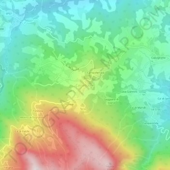
Name: Castelluccio topographic map, elevation, terrain.
Average elevation: 705 m
Minimum elevation: 419 m
Maximum elevation: 1,214 m
Make a donation
Gear up for your next adventure:
As an Amazon Associate, this site earns from qualifying purchases at no extra cost to you.
Other topographic maps
Click on a map to view its topography, its elevation and its terrain.
Castellaro
Italia > Emilia-Romagna > Bologna > Alto Reno Terme > Castelluccio > Campoferraio
Average elevation: 624 m
Granaglione
Italia > Emilia-Romagna > Bologna > Alto Reno Terme
Piccolo borgo che sorge tra i castagneti a 900 metri d'altitudine. Pochi abitanti, una decina d'inverno, si ripopola d'estate con i villeggianti. Tipicità di Casa Forlai.
Average elevation: 816 m
Rio Maggiore
Italia > Emilia-Romagna > Bologna > Alto Reno Terme > Porretta Terme
Average elevation: 454 m
Granaglione
Italia > Emilia-Romagna > Bologna > Alto Reno Terme
Piccolo borgo che sorge tra i castagneti a 900 metri d'altitudine. Pochi abitanti, una decina d'inverno, si ripopola d'estate con i villeggianti. Tipicità di Casa Forlai.
Average elevation: 816 m
Make a donation
Gear up for your next adventure:
As an Amazon Associate, this site earns from qualifying purchases at no extra cost to you.