Geolocate

San Francisco topographic map

Click on the map to display elevation.

About this map

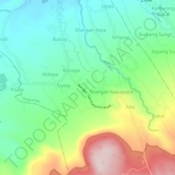
Name: San Francisco topographic map, elevation, terrain.

Location: San Francisco, Nagcarlan, Laguna, Calabarzon, 4002, Philippines (14.09024 121.40198 14.13024 121.44198)

Average elevation: 347 m

Minimum elevation: 215 m

Maximum elevation: 599 m

Other topographic maps

Click on a map to view its topography, its elevation and its terrain.

Gear up for your next adventure:

🥾Trail Hiking Socks - Comfortable socks to prevent blisters and fatigue
🕯️Camping Lantern - Illuminates your entire campsite with high-efficiency LEDs
🥾Waterproof Hiking Shoes - Durable shoes for wet and rugged trails
🧢Outdoor Visor - Breathable visor for sunny hikes
🧰Emergency Multi-Tool - Compact multi-tool for outdoor survival

As an Amazon Associate, this site earns from qualifying purchases at no extra cost to you.