Geolocate

Courbevoie topographic map

Click on the map to display elevation.

Courbevoie

La superficie de la commune est de 417 hectares ; l'altitude varie de 25 à 56 mètres.

About this map
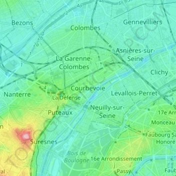
Name: Courbevoie topographic map, elevation, terrain.

Location: Courbevoie, Nanterre, Hauts-de-Seine, France métropolitaine, 92400, France (48.85533 2.21616 48.93533 2.29616)

Average elevation: 45 m

Minimum elevation: 19 m

Maximum elevation: 166 m

Gear up for your next adventure:

🧴First Aid Kit - Essential first aid supplies for outdoor emergencies
🛰️Satellite Messenger - Emergency communication for areas with no cell service
👟Leg Gaiters - Keep debris, mud, and snow out of your boots
🥾Hiking Leggings - Comfortable leggings for outdoor activities
🔨Vehicle Emergency Tool - Safety tool for remote road trips to trailheads

As an Amazon Associate, this site earns from qualifying purchases at no extra cost to you.