
Thank you for supporting this site ❤️
Make a donation
Make a donation
Gear up for your next adventure:
As an Amazon Associate, this site earns from qualifying purchases at no extra cost to you.
Kabonena topographic map
Click on the map to display elevation.
Thank you for supporting this site ❤️
Make a donation
Make a donation
Gear up for your next adventure:
As an Amazon Associate, this site earns from qualifying purchases at no extra cost to you.
About this map
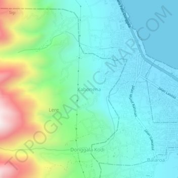
Name: Kabonena topographic map, elevation, terrain.
Location: Kabonena, Sigi Regency, Central Sulawesi, 94221, Indonesia (-0.90779 119.80502 -0.86779 119.84502)
Average elevation: 223 m
Minimum elevation: 0 m
Maximum elevation: 895 m
Thank you for supporting this site ❤️
Make a donation
Make a donation
Gear up for your next adventure:
As an Amazon Associate, this site earns from qualifying purchases at no extra cost to you.