Geolocate

Ponda topographic map

Click on the map to display elevation.

About this map

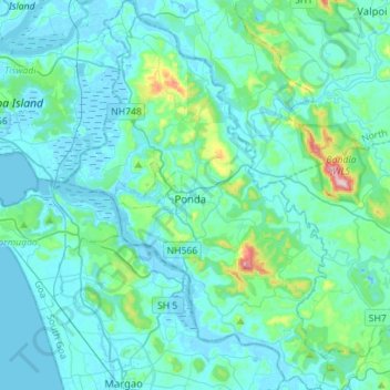
Name: Ponda topographic map, elevation, terrain.

Location: Ponda, South Goa, Goa, India (15.26870 73.91557 15.53900 74.10532)

Average elevation: 48 m

Minimum elevation: -7 m

Maximum elevation: 435 m

Gear up for your next adventure:

💧Hydration Pack - Hands-free hydration system for long hikes
🩹Moleskin Blister Pads - Direct protection for painful foot pressure points
🥾Hiking Shoes - Durable and comfortable shoes for trail hiking
🧰Survival Kit - Essential gear for emergencies in the wilderness
💡LED Headlamp - Hands-free illumination for night hiking and camping

As an Amazon Associate, this site earns from qualifying purchases at no extra cost to you.