Geolocate

Sant Pere de Ribes topographic map

Click on the map to display elevation.

About this map

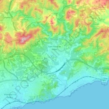
Name: Sant Pere de Ribes topographic map, elevation, terrain.

Location: Sant Pere de Ribes, Garraf, Barcelona, Catalonia, Spain (41.21850 1.72245 41.29471 1.83624)

Average elevation: 95 m

Minimum elevation: -1 m

Maximum elevation: 352 m

Other topographic maps

Click on a map to view its topography, its elevation and its terrain.

Gear up for your next adventure:

🔦UV Flashlight - Detect minerals or specific insects in the dark
🥫Freeze-Dried Meals - Lightweight, high-calorie nutrition for multi-day treks
🥽Outdoor Goggles - Protective eyewear for outdoor activities
🥾Trekking Boots - Durable boots for long-distance trekking
🎒Backpack Rain Cover - External shield to keep your entire pack dry

As an Amazon Associate, this site earns from qualifying purchases at no extra cost to you.