
Thank you for supporting this site ❤️
Make a donation
Make a donation
Gear up for your next adventure:
As an Amazon Associate, this site earns from qualifying purchases at no extra cost to you.
Yeniköy topographic map
Click on the map to display elevation.
Thank you for supporting this site ❤️
Make a donation
Make a donation
Gear up for your next adventure:
As an Amazon Associate, this site earns from qualifying purchases at no extra cost to you.
About this map
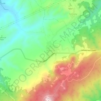
Name: Yeniköy topographic map, elevation, terrain.
Location: Yeniköy, Şarköy, Tekirdağ, Marmara Region, Turkey (40.62699 26.97939 40.66699 27.01939)
Average elevation: 197 m
Minimum elevation: 28 m
Maximum elevation: 446 m
Thank you for supporting this site ❤️
Make a donation
Make a donation
Gear up for your next adventure:
As an Amazon Associate, this site earns from qualifying purchases at no extra cost to you.