
Make a donation
Gear up for your next adventure:
As an Amazon Associate, this site earns from qualifying purchases at no extra cost to you.
Montemuro topographic map
Click on the map to display elevation.
Make a donation
Gear up for your next adventure:
As an Amazon Associate, this site earns from qualifying purchases at no extra cost to you.
Montemuro
A Serra de Montemuro é a oitava maior elevação de Portugal Continental, com 1382 metros de altitude. Situa-se nos concelhos de Arouca (distrito de Aveiro), Cinfães, Resende e Castro Daire e Lamego (distrito de Viseu) e entre as regiões do Douro Litoral e da Beira Alta.
Make a donation
Gear up for your next adventure:
As an Amazon Associate, this site earns from qualifying purchases at no extra cost to you.
About this map
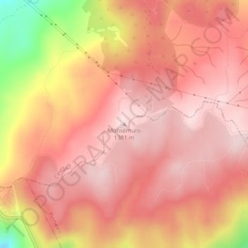
Name: Montemuro topographic map, elevation, terrain.
Average elevation: 1,277 m
Minimum elevation: 1,041 m
Maximum elevation: 1,366 m
Make a donation
Gear up for your next adventure:
As an Amazon Associate, this site earns from qualifying purchases at no extra cost to you.
Other topographic maps
Click on a map to view its topography, its elevation and its terrain.